
Projects
Earth Observing System (EOS) Aqua Advanced Microwave Scanning Radiometer
(AMSR-E)The EOS Advanced Microwave Scanning Radiometer (AMSR-E) on NASA's Earth Observing System Aqua spacecraft is scheduled for launch sometime in 2002. The AMSR-E will be used to study the Earth's hydrological cycle and will retrieve precipitation, soil moisture, snow cover, sea surface temperature, oceanic water vapor, cloud water, near surface wind speed, and sea ice parameters. (top)
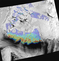
AMSR-E Sea Ice Animations
Arctic
Antarctic
AMSR-E Sea Ice Algorithms
The sea ice parameters to be retrieved from AMSR-E include sea ice concentration, sea ice temperature, and snow depth on sea ice. The sea ice concentration products will be generated using two algorithms: the enhanced NASA Team (NT2) algorithm (Markus and Cavalieri, 2000) and the AMSR Bootstrap algorithm (ABA). In the Arctic, the NT2 algorithm will be used to obtain the standard sea ice concentration, whereas in the Antarctic, the ABA algorithm will provide the standard product. In addition, the (ABA-NT2) and the (NT2-ABA) ice concentration differences will be provided for the Arctic and Antarctic, respectively. Sea ice temperature is a by-product of the ABA algorithm and the sea ice snow depth will be obtained from an algorithm described by Markus and Cavalieri (1998). The theoretical basis of these algorithms are described in the Algorithm Theoretical Basis Document (Cavalieri and Comiso, 2000).(top)
AMSR-E Sea Ice Validation
The accuracy of these products will be determined through the implementation of the AMSR-E Validation Plan . The plan consists of both Arctic (Cavalieri et al., 2002) and Antarctic post-launch field campaign components (Comiso et al., 2002). A pre-launch Arctic campaign called Meltpond2000 (Cavalieri, 2000) took place from June 25 through July 6, 2000 with the objective of quantifying the errors incurred by the AMSR-E sea ice algorithms resulting from the presence of melt ponds. Melt ponds are currently the largest single source of error in the determination of Arctic sea ice concentrations with satellite passive microwave sensors. (top)
Arctic Field Campaigns
Meltpond2000
Arctic 2003
Arctic 2006

Sea Ice Extent and Area Time Series from Satellite Microwave Radiometers
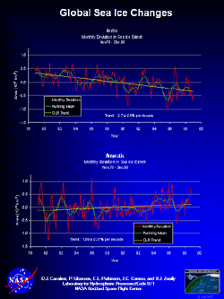
This project is a collaborative effort with Claire Parkinson to continue to develop and analyze sea ice data records derived from satellite passive microwave radiometers and is an extension of work undertaken by Goddard scientists including Cavalieri, Comiso, Gloersen, Parkinson, and Zwally. The aim of this work is to understand the role of the polar sea ice covers in the global climate system. In particular, we will study the long-term variability of the polar sea ice covers, quantify long-term trends, and seek to understand these changes in the context of changes in the ocean-atmosphere system.
Current Data Sets Derived from Satellite Microwave Radiometers
Arctic and Antarctic daily and monthly sea ice extents and areas were derived using Nimbus 7 SMMR and DMSP SSM/I data sets with the NASA Team sea ice algorithm which is summarized in Gloersen et al., 1992. The method of matching the time series of extents and areas from the different sensors is described in Cavalieri et al. (1999). Early and more recent results from combining these sensors have been reported by Cavalieri et al. (1997), Parkinson et al. (1999), Gloersen et al. (1999), Parkinson and Cavalieri (2002), and Zwally et al. (2002). Through 1998, these data sets were developed in a collaborative effort involving Cavalieri, Comiso, Gloersen, Parkinson, and Zwally. The extension beyond 1998 is being done by Cavalieri and Parkinson. Any use of these data should make reference to all five participants. (top)
Sea Ice Time Series Publications:1. Cavalieri, D. J., P. Gloersen, C. L. Parkinson, J. C. Comiso, and H. J. Zwally, Observed
Hemispheric Asymmetry in Global Sea Ice Changes, SCIENCE, 272, 1104-1106, 1997.2. Cavalieri, D. J., C. L. Parkinson, P. Gloersen, J. C. Comiso, and H. J. Zwally, Deriving Long-Term Time Series of Sea Ice Cover from Satellite Passive-Microwave Multisensor Data Sets, J. Geophys. Res., 104, 15,803-15,814, 1999.
3. Gloersen, P., C. L. Parkinson, D. J. Cavalieri, J. C. Comiso, and H. J. Zwally, Spatial Distribution of Trends and Seasonality in the Hemispheric Sea Ice Covers: 1978-1996, J. Geophys. Res., 104, 20,827-20,836, 1999.
4. Gloersen, P., W. J. Campbell, D. J. Cavalieri, J. C. Comiso, C. L. Parkinson, H. J. Zwally, Arctic and Antarctic Sea Ice, 1978-1987: Satellite Passive Microwave Observations and Analysis , National Aeronautics and Space Administration, Special Publication 511, Washington, D.C., pp.290, 1992.
5. Parkinson, C. L., and D. J. Cavalieri, A 21-year record of Arctic sea ice extents and their regional, seasonal, and monthly variability and trends, Annals of Glaciol., in press, 2002.
6. Parkinson, C. L., D. J. Cavalieri, P. Gloersen, H. J. Zwally, and J. C. Comiso, Variability of the Arctic Sea Ice Cover 1978-1996, J. Geophys. Res., 104, 20,837-20,856, 1999.7. Zwally, H. J., J. C. Comiso, C. L. Parkinson, D. J. Cavalieri, and P. Gloersen, Variability of Antarctic Sea Ice 1979-1998, J. Geophys. Res., in press, 2002.
Arctic Climate and Atmospheric Planetary Waves
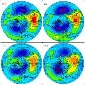
The goal of this work is to study the variability of sea level pressure (SLP) planetary waves and relate these planetary-scale variations to some of the climatic changes observed in the Arctic over the last fifty years. This work is in contrast to many recent Arctic climate studies that use EOF-defined indices such as the North Atlantic Oscillation, the Pacific North American, and Arctic Oscillation. Results suggest that the variations in phase of the two longest planetary SLP waves drive low frequency Arctic Ocean and sea ice variability (Cavalieri, 2002; Cavalieri and Häkkinen, 2001). (top)
Recent Publications:
Cavalieri, D. J., A link between Fram Strait sea ice export and atmospheric planetary wave phase, Geophys. Res. Lett., 20 (12), 10.1029/2002GL014684, 2002.
Cavalieri, D. J. and S. Häkkinen, Arctic climate and atmospheric planetary waves, Geophys. Res. Lett., 28(5), 791-794, 2001.


